Monday, 12 April 2010
Sunday: The Long Mynd
Distance: 37.9 km (23.55 mi)
Time: 7 hours
Average Speed: 5.41 km/h (3.36 mph)
Total ascent: 570m
This route was based on one from a walking guide, but extended to ~20 miles for the training schedule. The route is from the Jarrold guide for Shropshire, Staffordshire and Heart of England, with a couple of additions.
The weather forcast was good so I was in short sleeves from the start. The wind, when exposed to it, cooled things down significantly and other people were wrapping up warmer than I thought necessary but I am a Geordie. Genetically speaking, although we can still feel the cold we are incapable of admitting we fell the cold. Out of the wind it was certainly warm.
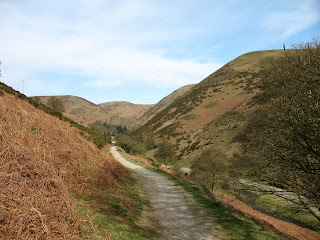
The route starts next to the Co-op in Church Stretton, climbing out of the town before dropping back down into the Carding Mill Valley. You then follow the valley before climbing up out of it to meet the Port Way. That climb certainly worked up a sweat and was good practice for Red Bank.
At the top the route is to turn left and head southwards along the Port Way, but I turned right and headed north until I felt I'd reached the end then looped around back to where I'd first hit the top. Along the way I helped a group of 5 lads unsure if they were still on the right path.
Back on the book's route I followed the Port Way over Pole Bank and on to Pole Cottage. At this point the route turns left to follow the path down to Little Stretton but I had a longer walk planned. I kept going along the top of the Long Mynd. For some reason the GPS lost its fix around this point and didn't get it back until I'd stopped for a much needed drink of water 15 minutes later.
At the gliding club I took the diverted path around the runway (the Starboard Way they call it) and kept going. They were using the ground tow for launching which is almost silent, except when the tow rope is dropping and they're rewinding it.
When it looked clear the path was heading downhill I stopped for my sandwiches. After that break it was straight on down until I'd almost reached the level of the road (about 7m above where I'd started), then followed the public bridleway left to come around the eastern side of the Long Mynd.
Once I'd worked my nerve up I turned left and climbed back up to the Port Way, rejoining it exactly where I'd stopped for lunch. Then I retraced my steps back to the path down to Little Stretton and rejoined the book's route.
Going down to Little Stretton is very steep, as the parents with the push chair coming the other way were discovering. I decided against a quick pint in the pub in Little Stretton, although it was very tempting. The final leg is a nice flat bit along the road from Little Stretton back to Church Stretton and the car park.
Reviewing the GPSs track data it got very confused at the top of Carding Mill, so I had to clean it up a bit before I could believe the distance and average speed data.
Labels:
k2b
Subscribe to:
Post Comments (Atom)


No comments:
Post a Comment